


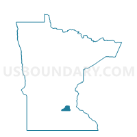
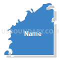
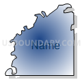
Blakeley Twp. Voting District, Scott County, Minnesota
About
Outline

Summary
| Unique Area Identifier | 604334 |
| Name | Blakeley Twp. Voting District |
| County | Scott County |
| State | Minnesota |
| Area (square miles) | 27.22 |
| Land Area (square miles) | 26.47 |
| Water Area (square miles) | 0.75 |
| % of Land Area | 97.24 |
| % of Water Area | 2.76 |
| Latitude of the Internal Point | 44.57626670 |
| Longtitude of the Internal Point | -93.86367000 |
Maps


Graphs
Select a template below for downloading or customizing gragh for Blakeley Twp. Voting District, Scott County, Minnesota


Neighbors
Neighoring Voting District (by Name) Neighboring Voting District on the Map
- Belle Plaine Voting District, Scott County, MN
- Belle Plaine Twp. Voting District, Scott County, MN
- Faxon Twp. Voting District, Sibley County, MN
- Henderson Twp. Voting District, Sibley County, MN
- Jessenland Twp. Voting District, Sibley County, MN
- Tyrone Twp. Voting District, Le Sueur County, MN
Top 10 Neighboring County Subdivision (by Population) Neighboring County Subdivision on the Map
- Belle Plaine city, Scott County, MN (6,661)
- Belle Plaine township, Scott County, MN (878)
- Henderson township, Sibley County, MN (728)
- Faxon township, Sibley County, MN (701)
- Tyrone township, Le Sueur County, MN (562)
- Jessenland township, Sibley County, MN (444)
- Blakeley township, Scott County, MN (418)
Top 10 Neighboring Place (by Population) Neighboring Place on the Map
Top 10 Neighboring Unified School District (by Population) Neighboring Unified School District on the Map
Top 10 Neighboring State Legislative District Lower Chamber (by Population) Neighboring State Legislative District Lower Chamber on the Map
Top 10 Neighboring State Legislative District Upper Chamber (by Population) Neighboring State Legislative District Upper Chamber on the Map
Top 10 Neighboring 111th Congressional District (by Population) Neighboring 111th Congressional District on the Map
Top 10 Neighboring Census Tract (by Population) Neighboring Census Tract on the Map
- Census Tract 813, Scott County, MN (8,440)
- Census Tract 9501, Le Sueur County, MN (7,001)
- Census Tract 9502, Le Sueur County, MN (4,526)
- Census Tract 1701.98, Sibley County, MN (4,305)